.svg)
File:2011 Census India literacy distribution map by states and union territories.svg

Size of this PNG preview of this SVG file: 220 × 237 pixels. Other resolutions: 223 × 240 pixels | 348 × 375 pixels | 1,500 × 1,615 pixels.
Original file (SVG file, nominally 1,500 × 1,615 pixels, file size: 1.89 MB)
Summary
| Description |
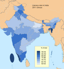
English: The map shows the average literacy rate for each state and union territories of India, as per 2011 census final numbers.
Source: Ranking of states and union territories by lireacy rate: 2011 Census of India, Ministry of Home Affairs, Government of India (2013) The world average literacy rate is sourced from UNICEF September 2012 report (= 84%). The disputed national borders SVG code used to create this map is a derivative work of File:India literacy rate map en.svg available on wikimedia commons. |
| Date | |
| Source | Own work |
| Author | M Tracy Hunter |
Licensing
I, the copyright holder of this work, hereby publish it under the following license:
This file is licensed under the Creative Commons Attribution-Share Alike 3.0 Unported license.
- You are free:
- to share – to copy, distribute and transmit the work
- to remix – to adapt the work
- Under the following conditions:
- attribution – You must give appropriate credit, provide a link to the license, and indicate if changes were made. You may do so in any reasonable manner, but not in any way that suggests the licensor endorses you or your use.
- share alike – If you remix, transform, or build upon the material, you must distribute your contributions under the same or compatible license as the original.
File history
Click on a date/time to view the file as it appeared at that time.
| Date/Time | Thumbnail | Dimensions | User | Comment | |
|---|---|---|---|---|---|
| current | 08:38, 28 April 2020 | | 1,500 × 1,615 (1.89 MB) | wikimediacommons>C1MM | Added data for Telangana and J&K/Ladakh separately |
File usage
The following 3 pages use this file: