.svg)
File:United Provinces 1903.gif

Original file (640 × 480 pixels, file size: 327 KB, MIME type: image/gif)
| Description |
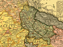
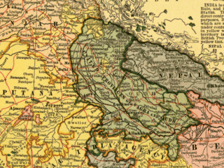
Map of United Provinces (India) |
||||
| Date | |||||
| Source |
From map of India by Dodd, Mead and Company, 1903. Library of Congress Geography and Map Collection. Call Number G7650 1903 .D6 TIL
|
||||
| Creator |
Unknown author |
||||
| Georeferencing | If inappropriate please set warp_status = skip to hide. | ||||
File history
Click on a date/time to view the file as it appeared at that time.
| Date/Time | Thumbnail | Dimensions | User | Comment | |
|---|---|---|---|---|---|
| current | 00:56, 17 September 2007 | | 640 × 480 (327 KB) | wikimediacommons>Taichi | {{Information |Description= Map of United Provinces (India) |Source= From map of India by Dodd, Mead and Company, 1903. Library of Congress Geography and Map Collection. Call Number G7650 1903 .D6 TIL {{PD-old}} |Date= 1903 |Author= |Permission= |other_ve |
File usage
The following 10 pages use this file: