.svg)
Aralvaimozhi
 Thank you for being part of the Bharatpedia family! 0% transparency: ₹0 raised out of ₹100,000 (0 supporter) |
Aralvaimozhi
Aramboly | |
|---|---|
Town | |
 | |
 Aralvaimozhi Location in Tamil Nadu, India | |
| Coordinates: 8°14′54″N 77°31′40″E / 8.2482°N 77.5278°ECoordinates: 8°14′54″N 77°31′40″E / 8.2482°N 77.5278°E | |
| Country | |
| State | Tamil Nadu |
| District | Kanniyakumari |
| Population (2019) | |
| • Total | 27,000 |
| Languages | |
| • Official | Tamil |
| Time zone | UTC+5:30 (IST) |
| PIN | 629301 |
Aralvaimozhi is a panchayat town in Kanniyakumari District in the state of Tamil Nadu, India. It is a small town situated in southern India. The town was earlier called as Aramboly during colonial period.
History[edit]
Aralvaimozhi pass was a strategically important gap or mountain pass in the southernmost end of Western Ghats. It connected erstwhile Travancore with Madras Presidency. Many of the invasions faced by the Chera and the successor kingdoms came via this ghat.
The name "Aral" was derived from the fort built and maintained by the rulers of Venad and later by the kingdom of Travancore to defend the kingdom from invasions from the east regions. It is also said that Aralvaimozhi means whispering wind. The whistling sound of wind in the region might have led to such a name.
Aralvaimozhi Fort was one of the most important forts of Travancore. It was constructed around 1740 by Eustachius De Lannoy along with Udayagiri Fort, Vattakottai Fort and Travancore lines.[1] The fort was captured by the English East India Company in 1809 from the soldiers loyal to Velu Thampi Dalawa. The remains of the fort can be seen near railway station, but neglected by both railway and archeology departments.
Culture[edit]
Aralvaimozhi is famous for a Catholic church located on the hill of Kattadi malai where Devasahayam Pillai was martyred.
Meenakshi Amman Temple (another attraction) in Aralvaimozhi was famous for its "Tamburan Villayatu" festival.
Economy[edit]
Its pincode is 629301. Muppandal Wind Farm is located in Aralvaimozhi Town Panchayat. This farm is the largest in Asia and supplies the villagers with electricity for their needs.[2][3] It is well known for being the greatest source of wind energy in Asia.
Poigai Dam, constructed in the year 2000 is serving water for irrigation purposes around the area. For the first time the dam was completely filled with water in 5 nov 2021 making it a wonderful place to visit.
Wind energy[edit]
The 1,500 megawatts (MW) Muppandal wind farm is the country's largest onshore wind farm which is the Asia's second largest windfarm.[citation needed] The project features a large number of wind turbines of varying sizes from 200 kilowatts (KW) to 1650KW.[citation needed]
Transportation[edit]
Railway station spelled "Aralvaimozhi", with station code AAY is situated here. It is connecting many employees of ISRO_ Mahendragiri campus.
Gallery[edit]

Remains of Aralvaimozhi fort found near railway station
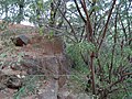
Remains of Aralvaimozhi fort found near railway station
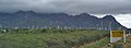
Aralvaimozhi railway station, with the wind-power mills in the background


See also[edit]
- Aryankavu pass
- Palakkad Gap
References[edit]
- ↑ Ananth, M. K. (19 July 2018). "Travancore: When an enemy became leader of Travancore army". The Times of India. Retrieved 12 October 2020.
- ↑ "Tapping the Wind - India". February 2005. Archived from the original on 21 February 2007. Retrieved 28 October 2006.
- ↑ Watts, Himangshu (11 November 2003). "Clean Energy Brings Windfall to Indian Village". Reuters News Service. Retrieved 28 October 2006.
External links[edit]
- News about heritage grinding stone found at Aralvaimozhi - reported in The Hindu
- Poigai Dam - In government's Water Resources Information System - Wiki
This Kanyakumari district location article is a stub. You can help Bharatpedia by expanding it. |