.svg)
Ariyannur Umbrellas
 Thank you for being part of the Bharatpedia family! 0% transparency: ₹0 raised out of ₹100,000 (0 supporter) |
| Ariyannur Umbrellas | |
|---|---|
| Native name Malayalam: അരിയന്നൂർ കുടക്കല്ല് | |
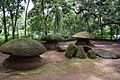
 A view of three umbrella stones | |
| Location | Thrissur, Kerala |
| Governing body | Archaeological Survey of India |
| Lua error in Module:Location_map at line 403: attempt to index field 'wikibase' (a nil value). | |
Template:Keralahistory
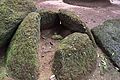
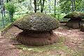
Ariyannur Umbrellas is a prehistoric Megalith burial site situated in Ariyannur in Kandanassery Panchayat of Thrissur District of Kerala. Archaeological Survey of India in 1951 declared it as a centrally protected monument. The site has six umbrella stones or mushroom stones, locally called Kudaikkallu. Of them, four are intact and two are partially broken.[1][2][3][4][5]
.
These are part of the larger Kudakkallu Parambu complex which is believed to be from ~2000 BCE.
Gallery[edit]
Ariyannur Umbrellas

Ariyannur Umbrellas

Ariyannur Umbrellas
Ariyannur Umbrellas
Ariyannur Umbrellas


References[edit]
- ↑ "ARIYANNUR UMBRELLAS". ASI Thrissur Circle. Retrieved 9 June 2013.
- ↑ "ARCHAEOLOGICAL SITES". go-kerala.com. Archived from the original on 10 July 2013. Retrieved 9 June 2013.
- ↑ "History". Culturalcapitalofkerala. Retrieved 9 June 2013.
- ↑ "Students prepare manual on flora". The Hindu. 4 March 2005. Archived from the original on 27 November 2007. Retrieved 9 June 2013.
- ↑ A Survey Of Kerala History. A Sreedhara Menon. 2007. ISBN 9788126415786. Retrieved 9 June 2013.
Tourist attractions in Thrissur | ||
|---|---|---|
| Dams |  | |
| Beaches and Waterfalls | ||
| Forts and Palaces | ||
| Boatraces | ||
| Parks and Zoos | ||
| Exhibitions and film festivals | ||
| Buildings | ||
| Festivals | ||
| Prehistoric | ||
| Museums | ||