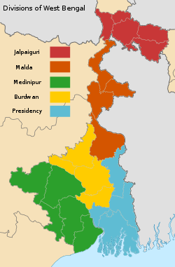
Medinipur division
Medinipur division | |
|---|---|
 | |
 | |
| Coordinates: 22°27′N 86°59′E / 22.45°N 86.98°ECoordinates: 22°27′N 86°59′E / 22.45°N 86.98°E | |
| Country | |
| State | West Bengal |
| Established | 2017 |
| Headquarters | Jhargram |
| Area | |
| • Total | 27,209 km2 (10,505 sq mi) |
| Population (2011) | |
| • Total | 17,536,354 |
| • Density | 640/km2 (1,700/sq mi) |
Medinipur division is one of the five administrative division in the Indian state of West Bengal.
History[edit]
Medinipur division was established in 2017.[1][2]
Geography[edit]
Medinipur Division is composed of the following districts:[1]
Medinipur division has an area of 27, 209 sq km.
Note: Since this division was created after the 2011 census, the data is calculated as the sum of the area of the above districts.
The division has its headquarters at Jhargram.[1]
Demographics[edit]
Medinipur division had a population of 17,536,354 in the 2011 census.
Note: Since this division was created after the 2011 census, the data is calculated as the sum of the population of the above districts.
| District | Area | Population As of 2011 |
|---|---|---|
| Paschim Medinipur | 6,398 sq km | 4,776,909 |
| Purba Medinipur | 4,736 sq km | 5,095,875 |
| Bankura | 6,882 sq km | 3,596,292 |
| Purulia | 6,259 sq km | 2,930,115 |
| Jhargram | 3,024 sq km | 1,137,163 |
| Total | 27,209 | 17,536,354 |
See also[edit]
List of administrative divisions in India
References[edit]
- ↑ 1.0 1.1 1.2 "The Kolkata Gazette dated March 20, 2017" (PDF). Personnel & Administration and e-Governance department, Government of West Bengal. Retrieved 3 July 2023.
- ↑ "Bengal to be divided into two more administrative divisions". Millenium Post. Retrieved 3 July 2023.
