Tonk district
Thank you for being part of the Bharatpedia family! 0% transparency: ₹0 raised out of ₹100,000 (0 supporter) |
This article needs additional citations for verification. (October 2014) |
Tonk district | |
|---|---|
| Country | India |
| State | Rajasthan |
| Division | Ajmer |
| Area | |
| • Total | 7,194 km2 (2,778 sq mi) |
| Population (2011) | |
| • Total | 1,421,326 |
| • Density | 200/km2 (510/sq mi) |
| Time zone | UTC+05:30 (IST) |
| Website | tonk.nic.in |
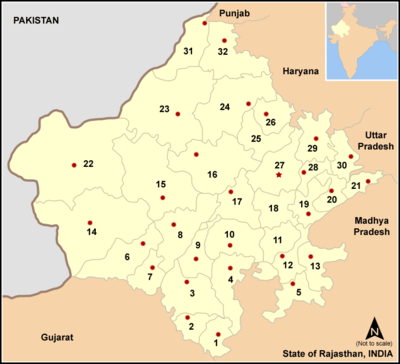
Tonk district is a district of the state of Rajasthan in western India. The city of Tonk is the administrative headquarters of the district. The district is bounded on the north by Jaipur district, on the east by Sawai Madhopur district, on the southeast by Kota district, on the south by Bundi district, on the southwest by Bhilwara district, and on the west by Ajmer district.
Geography[edit]
Tonk is on National Highway 12, 100 km from Jaipur. It is in the northeastern part of the state between 75.19' and 76.16 East longitude and 25.41' and 26.24' North latitude. The total area is 7194 km2 (as per 2002-03).
It is one of the four districts headquarters of Rajasthan state that are not directly connected with rail. The nearest railway station, Newai, is within the district but is 30 km from the district headquarters. Banas River flows through the district.
The district is notable for the Tonk meteorite, a rare carbonaceous chondrite meteorite that fell in 1911.[1]
Economy[edit]
In 2006, the Ministry of Panchayati Raj named Tonk one of the country's 250 most backward districts (out of 640).[2] It is one of the 12 districts in Rajasthan receiving funds from the Backward Regions Grant Fund (BRGF).[2]
Divisions[edit]
There are seven sub-divisions and tehsils: Deoli, Malpura, Newai, Todaraisingh, Tonk, Uniara and Peeplu. Tonk is Nagar-Parishad while Deoli, Malpura, Newai, Todaraisingh and Uniara are Nagar-Palikas. There were 1093 villages in the district according to the 2001 census.
Demographics[edit]
According to the 2011 census, Tonk district has a population of 1,421,326,[3] roughly equal to the nation of Swaziland[4] or the US state of Hawaii.[5] This gives it a ranking of 347th in India (out of 640).[3] The district has a population density of 198 inhabitants per square kilometre (510/sq mi).[3] Its population growth rate over the decade 2001-2011 was 17.33%.[3] Tonk has a sex ratio of 949 females for every 1000 males[3] and a literacy rate of 62.46%.[3]
At the time of the 2011 Census of India, 95.82% of the population in the district spoke Hindi and 3.81% Urdu as their first language.[6]
| Year | Pop. | ±% p.a. |
|---|---|---|
| 1901 | 260,801 | — |
| 1911 | 276,428 | +0.58% |
| 1921 | 255,216 | −0.80% |
| 1931 | 297,275 | +1.54% |
| 1941 | 329,790 | +1.04% |
| 1951 | 406,921 | +2.12% |
| 1961 | 497,729 | +2.03% |
| 1971 | 625,830 | +2.32% |
| 1981 | 783,635 | +2.27% |
| 1991 | 975,006 | +2.21% |
| 2001 | 1,211,671 | +2.20% |
| 2011 | 1,421,326 | +1.61% |
| source:[7] | ||
Culture[edit]
Pilgrimage sites[edit]
- Diggi Kalyan Ji Temple
- Dadabadi[8]
Historical Sites[edit]
Prominent towns where remanats of forts, palaces and architectural buildings, made by ancient kings and rulers, can be found:
References[edit]
- ↑ Endress, Magnus; Spettel, Bernhard; Bischoff, Adolf (1994). "Chemistry, petrography, and mineralogy of the Tonk CI chondrite: Preliminary results". Meteoritics. 29 (4): 462–463.
- ↑ 2.0 2.1 Ministry of Panchayati Raj (8 September 2009). "A Note on the Backward Regions Grant Fund Programme" (PDF). National Institute of Rural Development. Archived from the original (PDF) on 5 April 2012. Retrieved 27 September 2011.
- ↑ 3.0 3.1 3.2 3.3 3.4 3.5 "District Census 2011". Census2011.co.in. 2011. Retrieved 30 September 2011.
- ↑ US Directorate of Intelligence. "Country Comparison:Population". Retrieved 1 October 2011.
Swaziland 1,370,424
- ↑ "2010 Resident Population Data". U. S. Census Bureau. Retrieved 30 September 2011.
Hawaii 1,360,301
- ↑ 2011 Census of India, Population By Mother Tongue
- ↑ Decadal Variation In Population Since 1901
- ↑ "Pilgrim places of Tonk district". National Informatics Centre. Archived from the original on 24 February 2008.
External links[edit]
Coordinates: 26°09′48″N 75°47′13″E / 26.16333°N 75.78694°E


