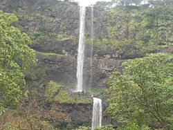
Vajrai Waterfall
Thank you for being part of the Bharatpedia family! 0% transparency: ₹0 raised out of ₹100,000 (0 supporter) |
This article has multiple issues. Please help improve it or discuss these issues on the talk page. (Learn how and when to remove these template messages)
|
The Bhambavli Vajrai Waterfall is a waterfall located on the Urmodi river in India.[1] It is approximately 27 kilometres (17 mi) from the city of Satara, Maharashtra,[2] near the village of Bhambavli[3] and Sahyadri Hill.[2] The height of the waterfall combining all three tiers is 560 metres (1,840 ft),[3] and is the second highest plunge waterfall in India, after the Nohkalikai Falls in Meghalaya, with a drop of 335 metres (1,099 ft).[2]
References[edit]
- ↑ Bagwan, Wasim A; Gavali, Ravindra S (2019). "Image Processing Based Vegetation Cover Monitoring and Its Categorization Using Differential Satellite Imageries for Urmodi River Watershed in Satara District, Maharashtra, India". In Hegadi, Ravindra S; Santosh, K. C. (eds.). Recent Trends in Image Processing and Pattern Recognition. Singapore: Springer Singapore. pp. 329–341. ISBN 9789811391866.
- ↑ 2.0 2.1 2.2 "Top things to do in Satara - Vajrai Waterfall". The Indian Trip. Retrieved 28 October 2020.
- ↑ 3.0 3.1 "Bhambavli Vajrai Waterfall". District Administration Satara. Retrieved 28 October 2020.


